Permo-Triassic Paleogeographic, Climate, Drainage and Topographic Maps of Africa
For methodology behind these maps, click here. For legend for these maps, click here . For paleotectonic maps at this level click here
To comment and contribute to these maps use form below
Click each map to expand
Click references to get full details and/or access
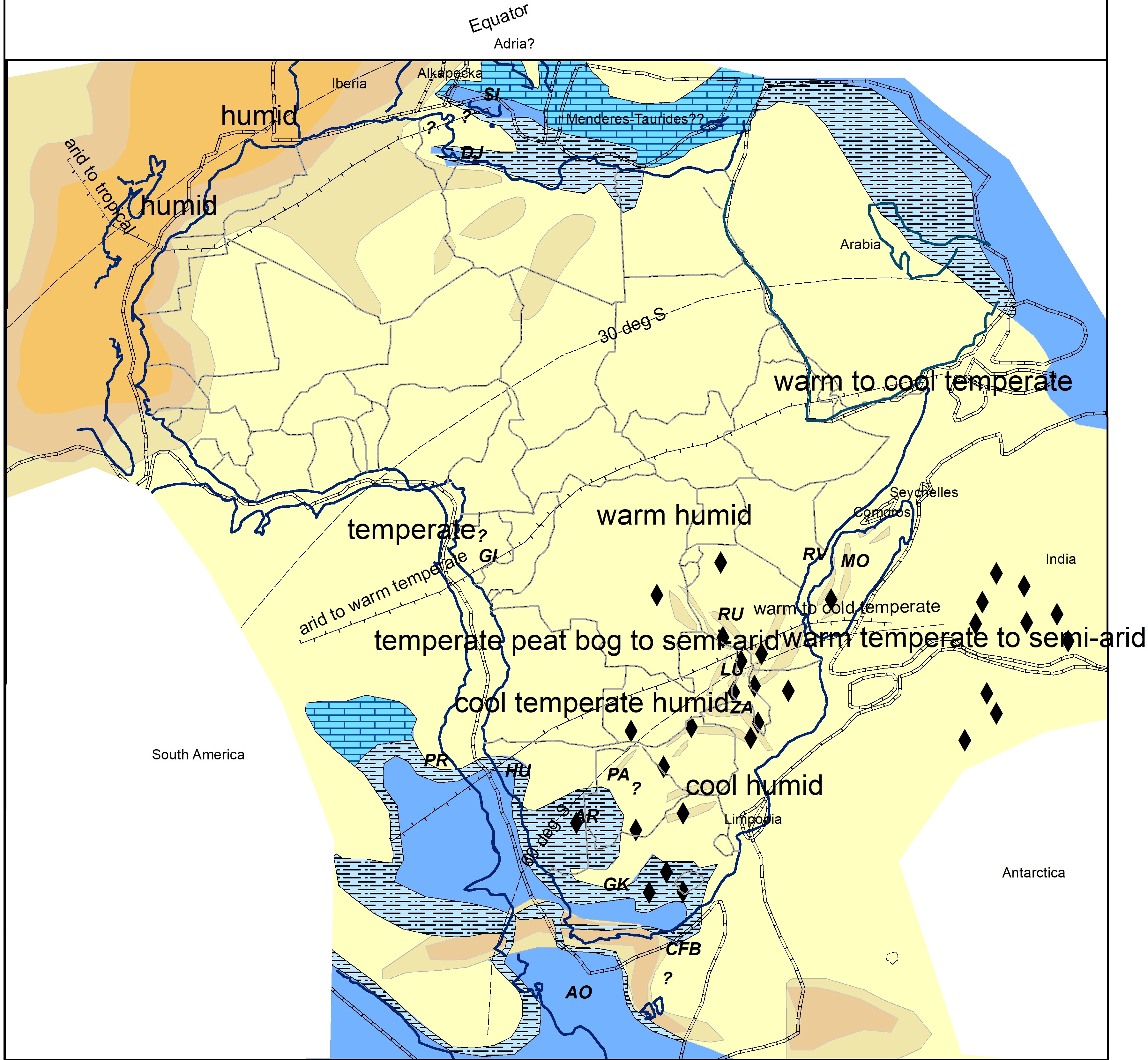
Kungurian 275+-5Ma
The main paleogeographic feature is a large enclosed, often anoxic, brackish sea within the foreland to the Cape Belt mountains (Bastos et al 2021) , covering the Parana and Great Karoo Basin, which is underfilled at this time. (Catuneanu 2005). The Permian rifts of southern Africa were in a syn-rift phase at this time, often being infilled by lacustrine shales (Macgregor, 2018). In the north, most topography is interpreted to be associated with a series of broad folds across North Africa that run parallel to the Hercynian belt that were the sites of later deep erosion represented by the Hercynian subcrop pattern. The Djeffara (DJ, Gabtni et al, 2009)) and Sicani (SI) rifts are infilled with shallow to deep marine strata, these basins seemingly bordering carbonate platforms occupying much of western Tethys (Scotese, 2017). It is puzzling, with the Hercynian belt close by, why are so few clastics in this region.
At this time the South Pole is located in Antarctica and Africa is entirely in the southern hemisphere, ranging from the paleoequator to approx 60 deg S. As would be expected for such a range, sedimentological descriptions indicate a wide range of environments ranging from humid tropical in Morocco (Olsen, 2000) to cool temperate peat bog in the coal belt (Cairncross, 2001) . Climate has warmed progressively from a glacial episode in the latest Carboniferous and continues to changes with time over the Permian as Africa rapidly moves northwards (Visser, 1995).
.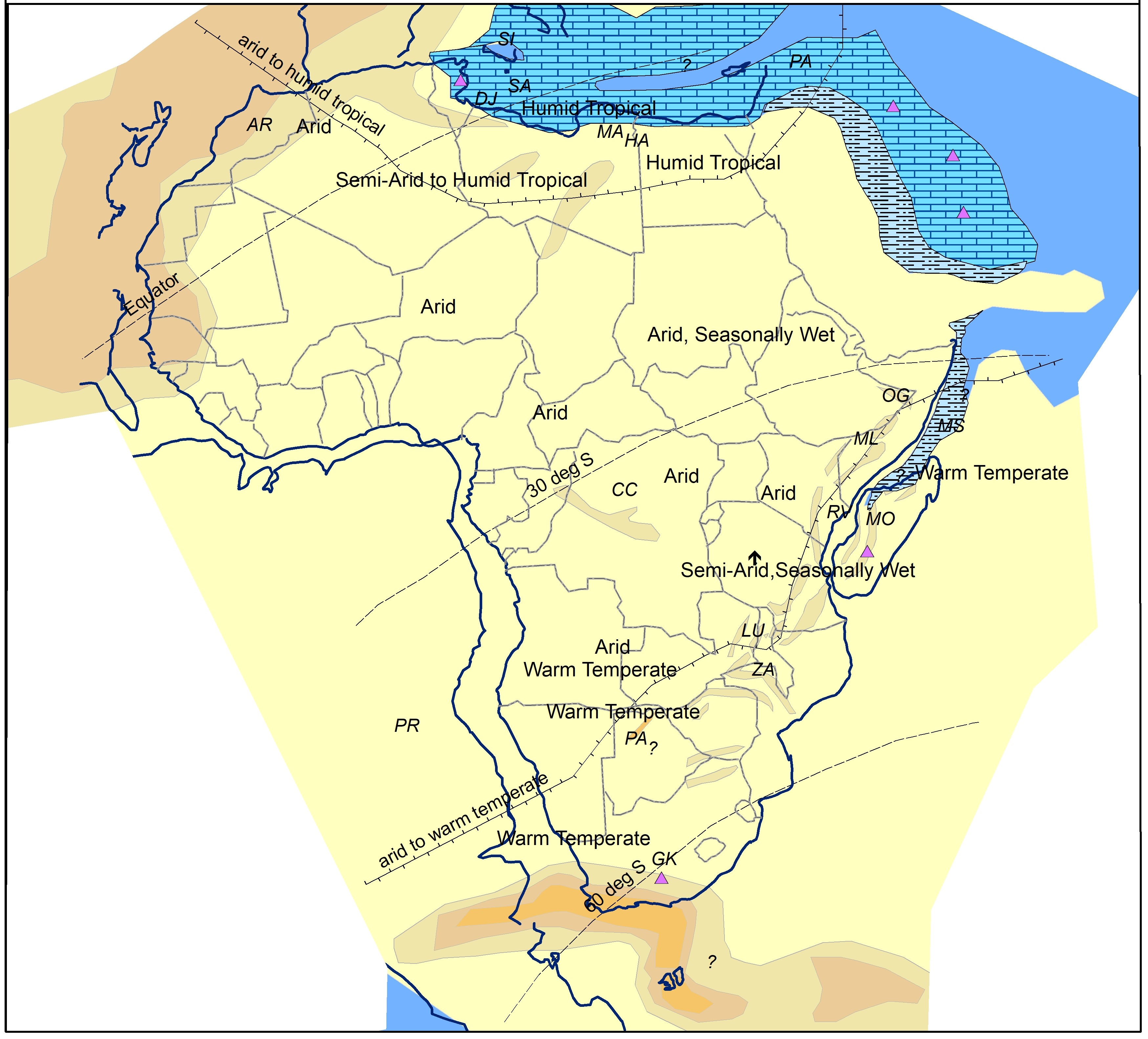
Induan 250+-5Ma
The Cape Mountains are now shedding sediment rapidly into the foreland basin, which is now in a filled phase (Catuneanu 2005), characterised by fluvial clastics. Rifting is diminishing in intensity in most of the southern Africa rifts, and these are also filled by fluvial clastics (Macgregor, 2018). Rifts further north are in a more active deeper phase. The main rift event in the Ogaden (OG) Basin is, for instance, of Early Triassic (Induan) age, during which a thick deep lacustrine shale (Bokh Shale) was deposited (Worku & Astin, 1992) , time equivalents of which are seen in the Mombasa Basin and Middle Sakamena Formation of the Morondava Basin in Madagascar. Madagascan rifts show more marine influence at this time than do the African ones (Wescott and Diggens, 1998), due likely to a marine inlet likely pulsating southwards from Tethys perhaps through the Somalian offshore rifts mapped by Davidson et al (2018)
Aridity is interpreted for all data points north of a warm temperate zone that covers the Cape Fold Belt and Permo-Triassic graben belt (Visser, 1995). This change does not just seem to be due to continental drift, which is now slowing. Particularly interesting is an interpreted change in Moroccan paleoclimates from humid tropical to arid (Olsen, 2000) , despite this area remaining close to the equator over the period.
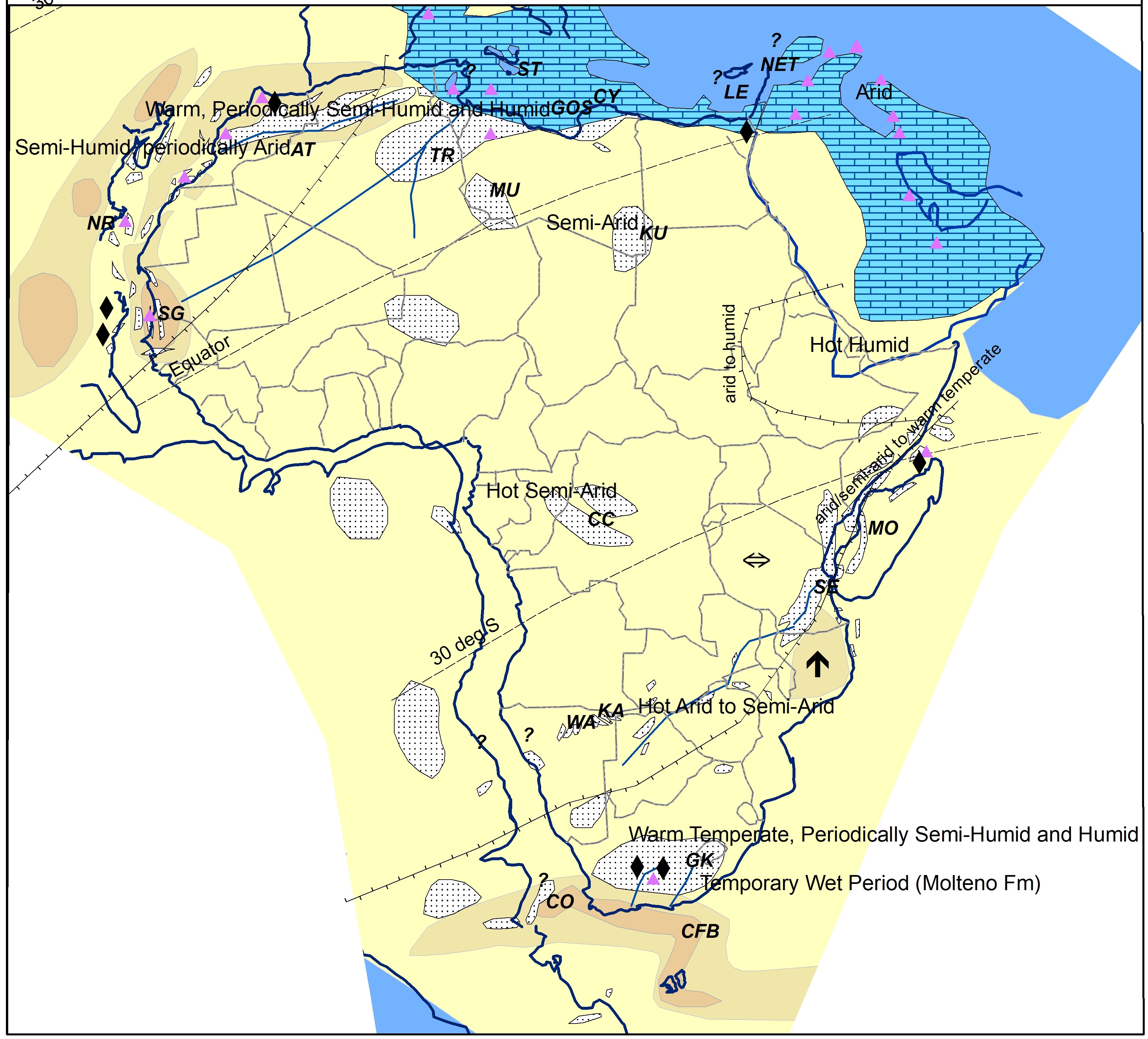
Carnian 230+-5Ma
Many of the rifts in southern Africa now seem to be in a phase of passive fill by fluvial redbeds (Macgregor (2018). Following a stratigraphic hiatus in the Ladinian which could mark the final movements on the Cape Fold Belt (CFB), the Great Karoo (GK) Basin is well into an overfilled phase (Catuneanu et al, 2005). The Djeffara Basin of Tunisia/Libya has now filled and is the site of carbonate-evaporite deposition (Khouni, 2018), consistent with the general carbonate-dominated sediment pattern of western Tethys.
Africa is now moving rapidly northwards, which as Africa is fixed on these maps, is shown as a southern migration of paleolatitude belts. The plotted data points on indicator minerals such as evaporites seem to indicate at least seasonal aridity over most of the continent (Boucot et al, 2013), with humid episodes around the NW African rifts (Olsen, 2000: Manspeizer, 1988) and in southern Africa. Many authors believe that parts of the Carnian were more humid than other Late Triassic eras. On the margins of the Great Karoo (GK) basin, the flora and fauna of the Molteno Formation (Cairncross, 2001) indicate warm temperate conditions with semi-humid and humid periods allowing marshlands to form. There are no indicators of the existence of any significant topography, though this interval is generally beyond the AFTA ‘clock’, so this may due to a lack of any surviving evidence in rocks of this ageKey Paleogeographical Maps Used
Key paleogeographic maps used at these levels include those of Hallett and Clark-Lowes (2016, Libya). D. Boote (unpublished, Libya), Guiraud at al (2005, N. Africa), Frizon et al (2008, Morocco), Chariot Oil (conf pres, Morocco), Ye et al (2017, NW/Equatorial Margin), Visser, 1995, Bastos et al (2021, Southern Africa/Brazil), Macdonald et al (2003, Southern Atlantic), Scotese (Paleomap Project), Torsvik and Cocks (2011, Africa), Ford and Golonka (2003, Global), Dercourt et al (2000, Europe), Barrier et al (2008, Middle East), Scotese (2017, Europe).
.